

Back of house and player facilities
Gate 2, featuring our Function Room
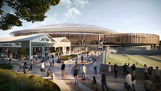
Entering the Macquarie Point Multipurpose Stadium
Inside the Macquarie Point Multipurpose Stadium
Meet some of the Stadium Design Team
Frequently asked questions
Did you know?
There is a 3D model of the Stadium in Red Square Creating a detailed 3D model of the Macquarie Point Multipurpose Stadium was a collaborative and creative process, bringing together architectural expertise, advanced technology and local craftsmanship. The model on display in Red Square was made using sustainable materials and cutting-edge techniques, designed to give the public a tangible glimpse of what's to come.
How does the height of the stadium compare? The edges of the Macquarie Point Multipurpose Stadium are 22.5 metres. The structure has a fixed-dome roof, which at the highest point is 51 metres. How does this height compare to other stadiums?
Transport We are planning our site to provide choices about how you can arrive and depart on event days, and every day. This includes setting targets to encourage public and active transport options. Our targets are based on best practice for moving large volumes of people to and from major events.
Sun and Shadowing As part of our design, comprehensive solar studies have been conducted to evaluate the stadium’s impact on nearby streets, properties, and the surrounding precinct. These studies included diagrams showing overshadowing conditions at 9 a.m. 12 p.m. and 3 p.m. during the Spring Equinox and the Winter and Summer Solstices. The analysis compared current shadow patterns at the site with those that would result from the proposed stadium and future developments. The stadium’s design features a transparent dome that has a low profile at the edges of the building and peaks over the center of the sports field, minimising shadowing impact on surrounding spaces. The dome’s gently sloping nature ensures that the bulk of the shadow falls underneath the stadium, aligning with the rear of the stands. This design limits the extent to which shadows are cast beyond the stadium’s boundaries. The north-eastern plaza: experiences minimal shadowing from the stadium year-round. The north-western plaza: sees little shadowing from the stadium or the relocated Goods Shed, but is subject to some afternoon overshadowing due to future developments in the area. The south-western plaza and Aboriginal Culturally Informed Zone: enjoy full sun from midday through the afternoon all year long. Evans Street: remains mostly unaffected in December, but begins to experience some shadowing after midday in March, and throughout the day in June. The south-eastern plaza: faces minor overshadowing in the morning during December and March but receives considerable shadow in June during early morning and late afternoon, with good sunlight access at midday. During the Winter Solstice, a small portion of the Davey Street walkway and the north-eastern side of Evans Street are in shadow at 9 a.m. with shadows retreating by midday. By 3 p.m. shadows are mostly confined to the development site. At the Spring Equinox, a small section of Davey and Evans Streets is in shadow at 9 a.m. but the shadow diminishes by midday. In the Summer Solstice, no shadowing occurs outside the stadium site. The overall impact of the stadium’s shadow is minor, particularly given the scale of the building, and it rarely extends beyond the development boundaries. Importantly, under no circumstance will the stadium or its surrounding structures cast shadows on the Cenotaph or the surrounding landscape, preserving the integrity of the site and ensuring the uninterrupted rising and setting of the sun for commemorative events.
Geotechnical Investigations There have been extensive geotechnical investigations at Macquarie Point over the last 10 years. Most recently we appointed WSP Australia to review over 700 existing borehole records and carry out additional tests to add to this data set. Latest Investigations: Drilled 20 new boreholes (2.7m to 28.82m deep), with 16 for geotechnical purposes and 4 to inform an acid sulfate analysis. Conducted 17 cone penetration tests (CPT) to measure soil properties, with depths from 1.46m to 11.2m. Collected rock and soil samples for lab testing, including soil chemistry, moisture content and rock strength. Site Conditions: The site is divided into three zones: Northern Zone: Mostly loose fill over dolerite rock due to past quarrying. Central Zone: Flat dolerite with estuarine deposits and fill. Southern Zone: Deeper fill and alluvial deposits shaped by ancient river channels. Key ground layers include: Fill: Loose, unstructured material. Estuarine and Alluvial Deposits: Layers of sand, gravel and clay. Dolerite Rock: Hard rock that varies in weathering. The data we have collected has been consolidated into a 3D model. These geotechnical investigations will help inform development across the site, including the Multipurpose Stadium.